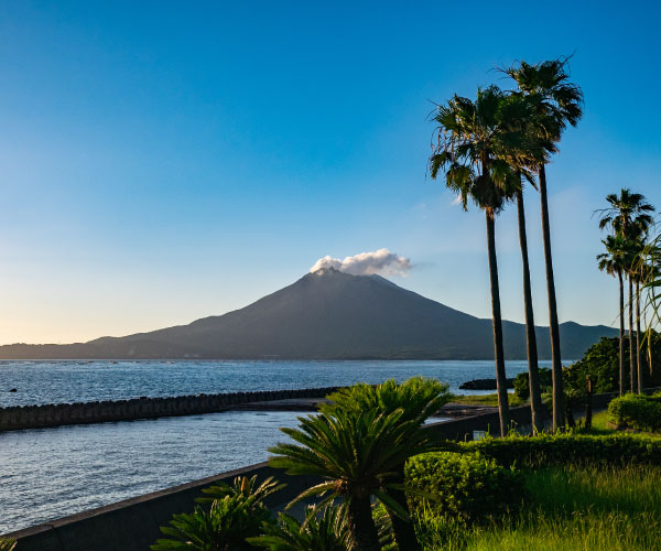
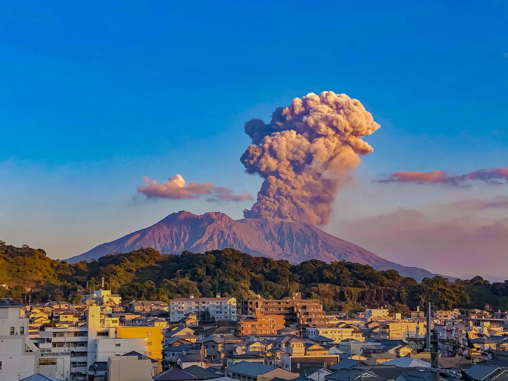
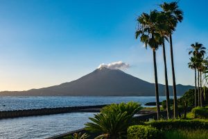
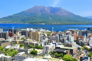
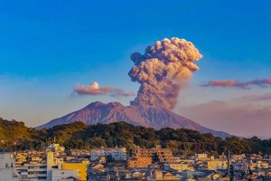
Sakurajima is one of Japan’s most active volcanoes, standing at 1,117 m and spanning approximately 80 km². Once an island, it became attached to the Ōsumi Peninsula following a massive eruption in 1914. Located just 4 km across Kagoshima Bay, the volcano features three peaks—North, Central, and the most active South Peak.
Volcano & History
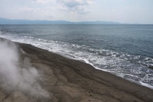
Erupts daily with gentle plumes of smoke and ash; occasional larger explosions occur.
The 1914 eruption was monumental, releasing about 10 billion tons of lava which closed the channel and merged the island to the mainland.
Despite being one of the world’s most dynamic volcanoes, around 4,500 residents live safely on its slopes under robust monitoring systems.
Activities & Sightseeing
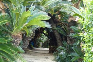
Nagisa Lava Trail: A 3 km path through centuries-old lava fields, now lush with pioneer vegetation.
Yunohira Observatory: At 373 m elevation, offering dramatic panoramic views of the peaks and Kagoshima city.
Visitor Center: Provides interactive exhibits on eruption history, geology, agriculture, and disaster preparedness.
Hot Spring Footbath: In Nagisa Park, a free 100 m foot bath filled with reddish-brown volcanic spring water.
Magma Onsen: Glass-walled bathhouses overlook the bay and volcano—ideal for sunset soaks.
Kurokami Buried Torii: A shrine gate buried by ash in 1914 serves as a powerful memory of volcanic force.
Tsukiyomi Shrine: A serene 8th-century shrine with pine groves and excellent volcanic views.
Dinosaur Park: A family-friendly zone with life-size statues and cherry blossoms—great for kids.
Outdoor Experiences
E‑bike and bike rentals: Circle scenic coastal roads and lava plains with eco-friendly transport.
Kayaking & SUP: Explore the bay’s western coast for unique views of Sakurajima from the water.
Island View Bus: A hop-on, hop-off bus links major attractions—perfect for a leisurely day trip.
Access & Transport
Ferry: Operates 24/7, running every 10–20 minutes; the trip takes ~15 minutes. Cars, bikes, and pedestrians are welcome.
By car/bus: Once on the peninsula, rent a car or hop on local buses; passes are available.
Bicycle: Station rentals near the terminal and Visitor Center make exploration easy.
Local Flavors
Sakurajima Daikon: The world’s largest radish, grown in mineral-rich volcanic soil.
Komikan Mandarin: Small, ultra-sweet oranges used in desserts and soft-serve ice cream.
Ferry Udon & Komikan Soft-serve: Enjoy local treats onboard or at island stalls.
Culture & Community
Living with an active volcano: The island’s residents wear helmets in school, and evacuation drills are routine.
Annual Events: The Sakurajima Marathon and volcanic art workshops celebrate the island’s unique spirit.
Kirishima, situated in southern Kyushu, is both a city and a volcanic mountain range within Kirishima-Kinkōwan National Park. It was Japan’s first national park in 1934, covering about 366 km². The region features a dramatic volcanic landscape with numerous peaks over 1,500 m, crater lakes, dense forests, and abundant hot springs.
Nature & Mythology
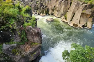
Volcanic Peaks & Crater Lakes: Iconic summits include Mt. Karakuni (1,700 m), Mt. Takachiho, and Mt. Shinmoedake. Hikers enjoy trails winding past emerald crater lakes like Onami Pond at 1,411 m.
Ancient Forests: Forests of chestnut, oak, pine, fir, and hemlock cover the mountains. Look out for vibrant azaleas in spring, fresh foliage in early summer, and fiery autumn leaves.
Mythic Legacy: Known as the “Land of the Gods,” Kirishima is tied to the Japanese creation myth—deities descended on Mt. Takachiho-no-mine. Numerous shrines and sacred trees mark these legends.
Hot Springs & Onsen Experiences
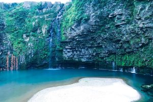
Volcanic Hot Springs: Multiple onsen towns such as Kirishima Onsen and Maruo Onsen offer relaxing bathhouses amid volcanic steam. Maruo even feeds a unique hot waterfall that glows in autumn mists.
Culture & Art
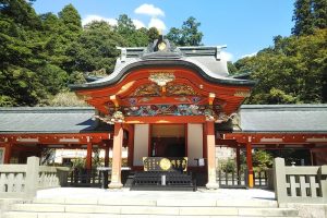
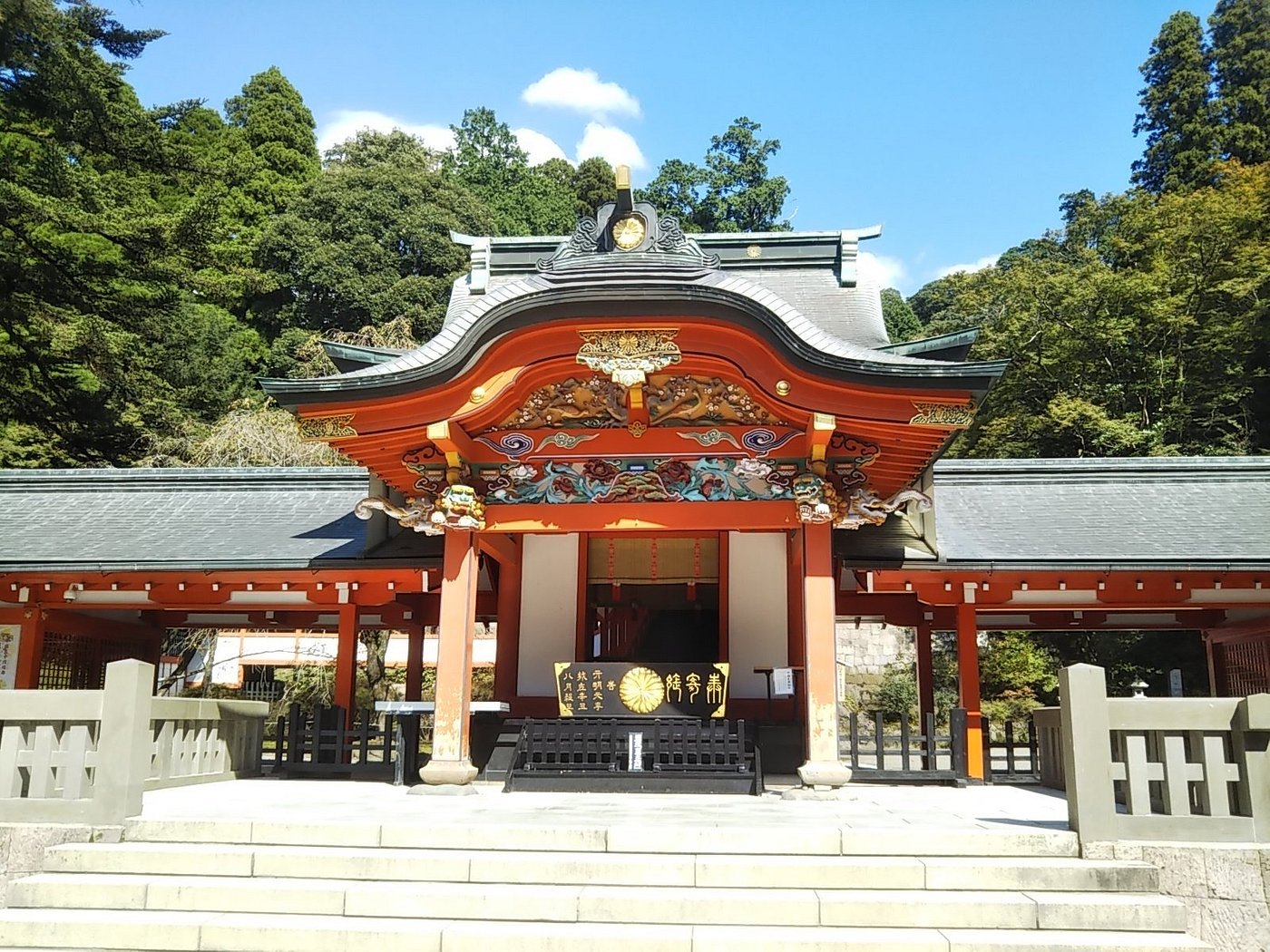
Kirishima Shrine: A powerful spiritual site founded in the 6th century, set within ancient forest. Often called “the Nikko of the West,” its wooden halls and cedar walkways are nationally treasured.
Kirishima Open Air Museum: Located at 700 m elevation, this outdoor art park blends sculptures and installations with panoramic mountain views.
Matsushita Museum of Art: Built in 1983, it displays Japanese and Western art across six themed buildings—from Monet and Picasso to local works and traditional crafts.
Activities & Adventures
Hiking & Trekking: Options range from gentle walks with crater lake views to multi-day volcanic summit hikes.
E-biking & Trail Stamping: Eco-friendly e-bike roads and “mountain stamp” challenges encourage exploration while preserving nature.
Seasonal Festivities:
Azalea Festival (late April–May)
Open-Air Concerts against mountain backdrops
Autumn Foliage Festival (Oct–Nov)
Winter illuminations and rare early snow on high peaks
Access & Transport
By Air: Kagoshima Airport within Kirishima City connects to major cities.
By Train: JR Kagoshima-Chūō → Hayato, Kokubu, or Kirishima-Jingū Station (~30–50 min).
By Car/Bus: Accessible via Kyushu/East-Kyushu Expressways; rental cars recommended for onsen/peak visits. Hourly buses serve key areas; onsen hop-on ticket covers local loops.
Heritage & Hot Tips
Ōsumi Kokubun-ji Ruins: Traces of a 8th-century Nara-period temple, now preserved as a historic site.
Kokubu Castle Ruins: 17th-century stone walls and moats mark this Shimazu clan structure.
Kirishima’s Black Vinegar & Shochu: Taste local black vinegar from traditional jar fermentation and premium sweet-potato shōchū from volcanic plateau crops.
Tanegashima, part of the Ōsumi Islands in Kagoshima Prefecture, is roughly 445 km² and home to about 33,000 people. The terrain is mostly flat, peaking at just 282 m. It lies about 115 km south of Kagoshima and 40 km east of Yakushima, boasting a humid subtropical climate.
Space & History
Tanegashima Space Center: Japan’s largest rocket-launch facility, spanning nearly 10 million m². Established in 1969 and run by JAXA, it handles satellite assembly, testing, tracking, and launches. The site features guided tours and a free space museum with full-size rocket replicas.
Gun History: Portuguese firearms first landed in Japan here in 1543. The Teppokan Gun Museum, shaped like a ship, displays antique firearms and related documents.
Nature & Marine Life
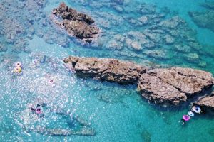
Beaches & Marine Sports: Beaches like Nagahama, Urada, and Kumano offer swimming, snorkeling, diving, surfing, fishing, kayaking, SUP, and packrafting. Loggerhead turtles also nest here.
Sea Caves & Mangroves: The southeast coast features dramatic sea caves such as Chikura Cavern. Tanegashima also marks Japan’s northern mangrove limit.
Tropical Forest Bathing: Forests of tall ferns offer peaceful nature walks and relaxation.
Outdoor & Culture
Cycle Routes: The “Tanegashima Route” is a 160 km coastal loop with ocean views and sugarcane fields.
Marathon & Events: The annual “Rocket Marathon” celebrates the island’s space legacy in March.
Access & Transport
Air: Flights from New Tanegashima Airport to Kagoshima take about 30 minutes.
Ferry: Jet ferry (~1.5 hours) and car ferry (~3 hours 40 minutes) are available from Kagoshima.
Island Transit: Renting a car is recommended. Buses run hourly (07:00–18:00); passes are available. Scooters and bikes are also common.
Food & Local Flavors
Anno Potato: A sweet yam unique to the island, used in many local sweets.
Seafood & Metalwork: Tanegashima is known for fresh seafood and artisan-made knives used by chefs and bonsai masters.
Archaeology & Heritage
Sites like Yokomine and Hirota in Minamitane feature Paleolithic and Yayoi–Kofun archaeological ruins, including shell-midden cemeteries.
Yakushima is a UNESCO World Heritage island off Kagoshima, spanning 504 km², 21% of which is heritage-protected forest. The towering Mt. Miyanoura reaches 1,936 m, with steep terrain rising straight from the coast—a compact vertical world from subtropical shoreline to subalpine summit.
Legendary Forests & Biodiversity
Millennial Yakusugi cedars: The iconic Jōmon Sugi, between 2,170–7,200 years old, anchors the island’s legend and spurred conservation efforts.
Vertical vegetation zones: Walk from lush evergreen, through cedar forests, up to bamboo grasslands and mountain heath near the summit.
Enchanted mossy woods: Trails like Shiratani Unsuikyo resemble Ghibli’s Princess Mononoke—deep moss, ancient giants, dreamy waterfalls.
Wildlife & coastal ecosystems: Spot Yakushima macaques, deer, rare gecko species, and nesting sea turtles on beaches like Nagata-hama.
Hiking & Outdoor Adventures
Classic trails:
Jōmon Sugi hike: 10–11 h round-trip via the Arakawa trail.
Shiratani Unsuikyo: A 3–4 h trek through moss-carpeted forest with ancient cedars.
Summit treks: Climb Mt. Kuromi (1,831 m) or Mt. Nagata (1,886 m)—prepare for full-day ascents.
Coastal & marine life: Visit Nagata-hama for turtle nesting (May–Aug), or relax in seaside onsen.
Getting Around & Access
By air: Flights ~40 min from Kagoshima, ~70 min from Fukuoka, ~95 min from Osaka.
By ferry: Jetfoil ~2–3 h; car ferry ~4 h.
Local transport:
Rental cars, scooters, and bikes are the best way to explore.
Buses run along the coastal ring (about hourly from 07:00–18:00); inner routes are less frequent. Bus passes are available.
Taxis are available but costly.
Food & Local Flavors
Unique island dishes: Turtle barnacle (“kamo-no-te”), flying-fish delicacies, venison, and citrus like tankan & ponkan.
Hot springs by the sea: Perfect to unwind after trekking.
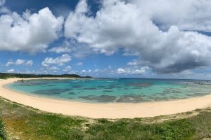
Yoronjima, also called Yoron, is the southernmost inhabited island of the Amami archipelago, part of Kagoshima Prefecture. Covering just 20.8 km², with around 6,000 residents, its highest elevation is 98 m, and it lies roughly 22 km north of Okinawa’s Hedo Point and 563 km south of Kyushu. The entire island sits on uplifted coral reef fringed by an emerald-green reef.
Nature & Beaches
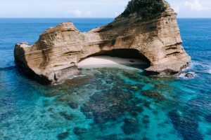
Yurigahama Sandbar: A “phantom beach” that appears ~1.5 km offshore at low tide between spring and autumn, surrounded by star-shaped sand and turquoise waters. Voted one of Japan’s top 50 must-see spots.
Ooganeku Beach & Minata Coast: Home to clear lagoons perfect for snorkeling, kayaking, sea-kayaking, glass‑bottom boat rides, and seeing sea turtles.
Marine & Sky Views: Renowned for stargazing—recognized as Japan’s darkest night skies, and ideal for full moon dance festivals.
Culture & Heritage
Yoron Kenpō: A traditional ceremonial drinking rite involving shell cups, speeches, and communal shōchū—so integral it’s included in the island constitution.
Ryukyuan & Okinawan Influences: Influences visible in Eisa drumming/dance, folk village architecture (thatched roofs), Greek‑style photo spot (“Mykonos Street”), and a fictional “Yoron Station” built for fun.
Folk Village & Southern Cross Center: Preserves island life heritage and offers exhibits and an observatory with sweeping views of Okinawa and Okinoerabu.
Economy & Local Life
Agriculture & Fisheries: Main crops include sugar cane, sweet potatoes, floriculture and traditional brown‑sugar shōchū. Sea salt and star‑sand collection are also local staples.
Cuisine & Treats: Unique offerings like shaved‑ice stand ‘Misaki,’ local seafood and Okinawa‑style dishes alongside friendly izakayas and cafés .
Access & Transport
By Air: Yoron Airport connects daily to Kagoshima, Amami Ōshima, and Okinawa with regional carriers.
By Sea: Ferries from Kagoshima (~20 hours) or Okinawa (~2.5–5 hours) call at Yoron Port.
On-Island Transit: Best via rental car, bicycle or scooter; limited buses and taxis available .
Okinoerabu, part of the Amami Islands in Kagoshima, spans ~93.7 km² (20 km long × 7 km wide), with a population near 14,000. It lies about 540 km south of Kyūshū and 60 km north of Okinawa. Much of the island is within Amami Guntō National Park.
Nature & Scenic Spots
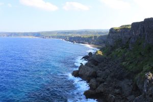
Rising coral terrain & mild peaks: The island is an uplifted coral island featuring limestone bedrock. The highest point is Mount Ōyama (246 m). The southern and western coasts are rugged with cliffs and natural limestone caves.
Limestone cave system: Over 200–300 caves formed by underground water erosion; highlights include Shōryūdō (600 m accessible), and Shōryūdō, a designated natural treasure—accessible without gear—along with the famous Shōryūdō and Shōryūdō.
Sea cliffs & sea‑blow caves: Spots like Tanae Misaki Cape and “Fūcha” blow-holes create spectacular ocean-spray shows; accompanied by coral reefs and sea turtles.
Subtropical flora: Known as the “Flower Island,” it features fields of Erabu lilies, freesia bulbs, and other blooms.
Culture & Heritage
Ryukyuan‑Okinawan culture: Strong Okinawan influence seen in dialect, folk songs, festivals, and lich-year traditions.
Saigō Takamori exile memory: The celebrated samurai was exiled here in 1862; today, the Nanshū Shrine and memorial commemorate his stay.
Sumiyoshi Shell Midden: A Jōmon–Yayoi period shell midden in China Town and classified as a national historic site.
Economy & Local Living
Agriculture & floriculture: Major in sugar cane, sweet potatoes, coffee, kikurages mushrooms, and vibrant bulbs (e.g., lilies) .
Food & drink: Local specialties include brown sugar (kokutō) shōchū, red‑soil potatoes, sea urchin, erabu coffee.
Activities & Highlights
Caving: Options range from easy Shōryūdō cave walks to 2–5 hr guided expeditions with full gear.
Diving & snorkeling: Clear waters (up to 40 m visibility) offer serene dives with sea turtles amid reefs.
Cycling & scenic drives: Flat roads across red soil fields, coastal cliffs, and eucalyptus groves—perfect for self-guided or guided tours.
Eco‑tours & festivals: Take part in beach clean‑ups, upcycling workshops, or local events like flower-planting and summer port festivals with boat races and bull sumo .
Access & Transport
Flights: Served by Okinoerabu Airport (OKE) with connections to Kagoshima (≈1h40m), Amami (≈35m), Tokunoshima, and Okinawa via regional carriers JAL/JAC.
Ferries: Ships call at Wadomari and China ports from Kagoshima, Amami, Okinawa, and Kobe/Osaka (long-distance).
Island transport: Best explored by rental car, taxi, or bike; public buses limited. Wi‑Fi hotspots available in airport and ports.
Tokunoshima is the second-largest island in the Amami archipelago, covering approximately 247.8 km², situated about 489 km south of Kyushu and 100 km north of Okinawa. Its terrain includes coastlines, mild mountains (highest peak: Inokawadake at 645 m), and the island is nestled within Amami Guntō National Park
Nature & Wildlife
Rich biodiversity: Home to rare creatures like the Amami rabbit, Tokunoshima spiny rat, Lidth’s jay, and the venomous habu snake.
Coral coastlines: Stunning beaches such as Aze Prince Beach, Yonama, and Kinenhama are ideal for snorkeling, swimming, and diving.
Unique formations: Innojofuta Park and coastal cliffs are sculpted by ancient coral erosion.
Culture & Tradition
Bull sumo (tōgyū): A 400-year-old tradition where bulls lock horns to determine dominance. Around 20 bouts yearly across 13 rings.
Longevity culture: Nicknamed “Island of Longevity,” it produced multiple supercentenarians recognized worldwide.
Ryukyuan heritage: Influenced by Ryukyuan and Okinawan cultures—local dialects (shimaguchi), folk music (shimauta, sanshin), and dances (eisa) are still alive.
Economy & Local Life
Agriculture: Major sugar cane production (used for kokuto sugar and shōchū), sweet potatoes, rice, ginger, tropical fruits like mangoes. Annual harvests often accompanied by shima-uta chanting .
Fishing & tourism: Coastal and marine activities, along with cultural tourism, supplement the economy .
Activities & Attractions
Outdoor pursuits: Snorkeling, scuba diving, surfing, and triathlon events in June–July.
Historical sites: Visit Omonawa Shell Midden—Jōmon/Yayoi era archaeological remains.
Golf & leisure: Three golf courses, scenic drives across the island, and serene beaches .
Access & Transportation
Flights: Daily flights from Kagoshima (~65 min) and Amami (~35 min).
Ferries: Connections to Kagoshima, Amami Ōshima, Okinoerabu, and Okinawa .
Island transport: Rent cars, e-bikes, use taxis or public buses; free Wi‑Fi at airport and ports .
Kikaijima is a small coral‐reef island (56.9 km²) in Kagoshima Prefecture, part of the Amami archipelago, located about 25 km east of Amami Ōshima and some 380 km south of Kyūshū. The island’s highest point reaches just 214 m – mostly flat – and it is renowned for its annually rising limestone plateau: uplifted coral reef that grows at around 2 mm per year, one of the fastest in the world.
Nature & Scenery
Beaches & lagoons: Sugira (Nakazato) Beach, right next to the airport, features calm lagoons ideal for swimming, snorkeling, SUP and family fun. Other seaside gems include Onotsu, Ikeji, and the famous “Hawaii Beach”.
Butterfly hotspot: The warm climate fosters thousands of colorful butterflies, like Chestnut Tiger and Tree Nymph, visible along “Butterfly Road” near Hyakunodai from spring to autumn.
Coral stone walls & banyan trees: Explore Aden Village’s coral walls (used for shade and typhoon defense) and visit the majestic Tekuzuku Banyan Tree (100+ years old, 17 m high, 42 m spread)
Scenic routes: Cycle or drive along the “Sugar Road” through endless sugar cane fields, or ascend to Hyakunodai Observatory (203 m) for panoramic views.
Science & Heritage
Geological treasure: Kikaijima’s uplifted coral reef terraces (formed ~100,000 years ago) were recently recognized as a UNESCO Geological Heritage Site.
Coral reef research hub: The KIKAI Institute for Coral Reef Sciences hosts international researchers studying reefs, sea-level change, and ecological adaptations.
Fossils & tunnels: Explore limestone caves and ancient underground tunnels carved into coral rock.
Economy & Local Flavor
Agriculture: Rich coral soils support sugar cane, citrus (Kikai‑mikan), brown sugar (“kokuto”), and Kikaijima-grown white sesame – Japan’s largest white sesame producer.
Cuisine specialties:
Goat dishes (karajuri, sashimi) from Amami tradition.
Brown sugar treats (gomagashi), sesame dressings/oils, Keraji pepper & island tomatoes.
Local shōchū distilled from kokuto brown sugar.
Access & Getting Around
By air: JAL flights from Kagoshima (~80 min, 2/day) and Amami Ōshima (~20 min, 3/day) .
By ship: Once-daily ferry from Kagoshima (~11 h) and Amami Ōshima (~2 h).
On the island: Rent a car or e-bike (e.g. e‑bike tours ~3.5–7 h start from tourist center) .
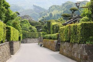
Located in the inland northwest of Kagoshima Prefecture, Naka‑Satsuma (Satsuma Town) spreads across 303.9 km² with about 18,400 residents. Facing the East China Sea, it serves as a gateway to Kagoshima, blending coastal panoramas with a rich inland heritage .
Natural Beauty & Outdoors
Scenic landscapes: rolling hills, emerald-green rivers (like Sendai River), plus lush Satoyama countryside and firefly habitats near Mt. Shibi .
Hot springs: enjoy unique baths like Myoken Onsen and other local hot spring sites.
Cherry blossoms: Hanami spots such as Yoshino Park offer views of 234 m hilltop vistas with sakura and Sakurajima in the distance.
Culture & Experiences
Pottery (Satsuma-yaki): Originating in nearby Miyama, with clay from this region and Korean potter influence. Local kilns offer workshops & sales of white, black, and porcelain-style ware.
Traditional crafts: ash painting (using Sakurajima volcanic ash), bamboo crafts, paper-cutting, even making artisanal ball‑pens from Oshima pongee.
Dolphin watching: Boat tours in Kinko Bay spot local dolphins against Sakurajima’s backdrop.
Herb & wild edible workshops: Learn about local medicinal plants and their uses .
Attractions & Landmarks
Yunohira Observatory at Mars Tsunuki Distillery: Offers scenic views and insight into Kagoshima’s whisky heritage.
Terukuni Shrine and Sengan‑en Garden: Part of broader Kagoshima sightseeing, easily accessible from Naka‑Satsuma.
Sogi Falls Park: A spiritual retreat surrounded by verdant nature.
Local Flavors
Kagoshima Kurobuta pork: Enjoy shabu‑shabu, tonkatsu, kakuni, and more at local farm-to-table venues.
Fresh seafood: Coastal location ensures an abundance of fish and kampachi from Kinko Bay.
Convenient Access
It’s centrally positioned on routes leading into Kagoshima City, with easy access by regional roads and JR/local rail lines. The City View bus in Kagoshima also connects to local attractions.
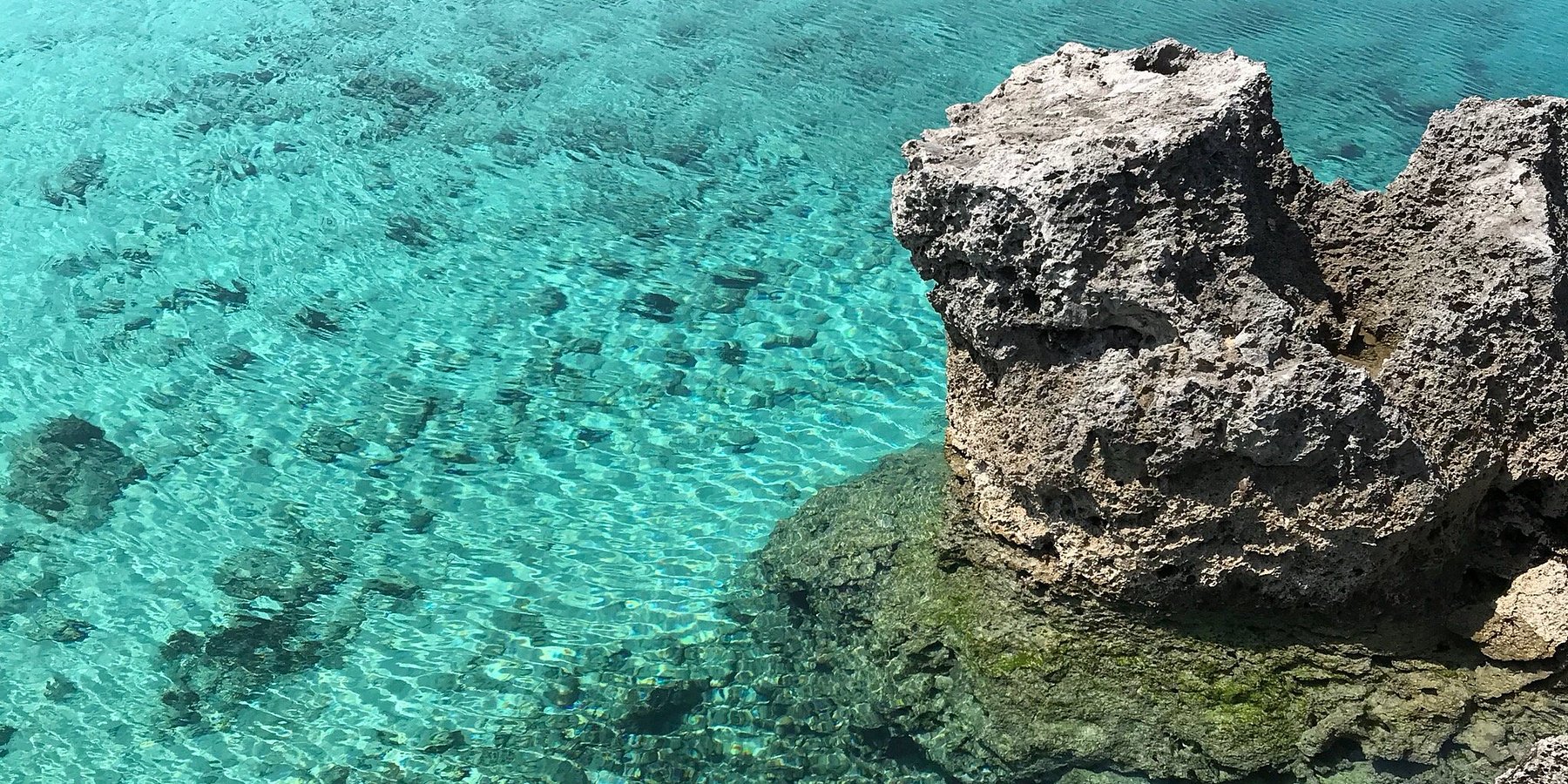
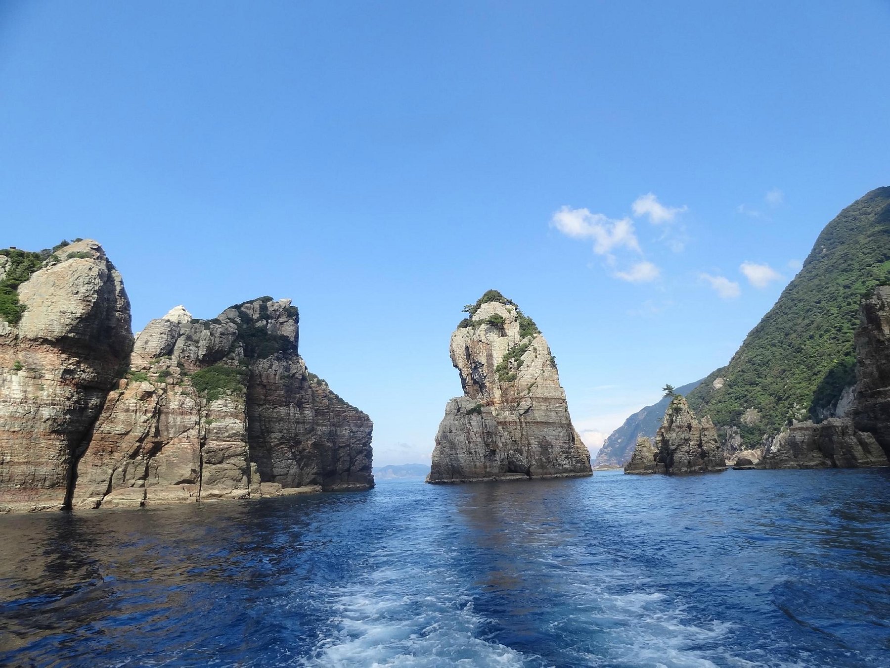
Koshikishima Islands lie in the East China Sea, approximately 30–38 km west off Satsumasendai, Kagoshima. Consisting of three inhabited main islands—Kamikoshiki-jima, Nakakoshiki-jima, and Shimokoshiki-jima—and numerous smaller islets, the chain spans roughly 35–39 km in length with a total land area of 118.7 km² and a population of about 5,600 (2010)
Established as a Quasi-National Park in March 2015, the protected area covers 54.5 km² of land and 252.9 km² of surrounding waters.
Nature & Scenic Spots
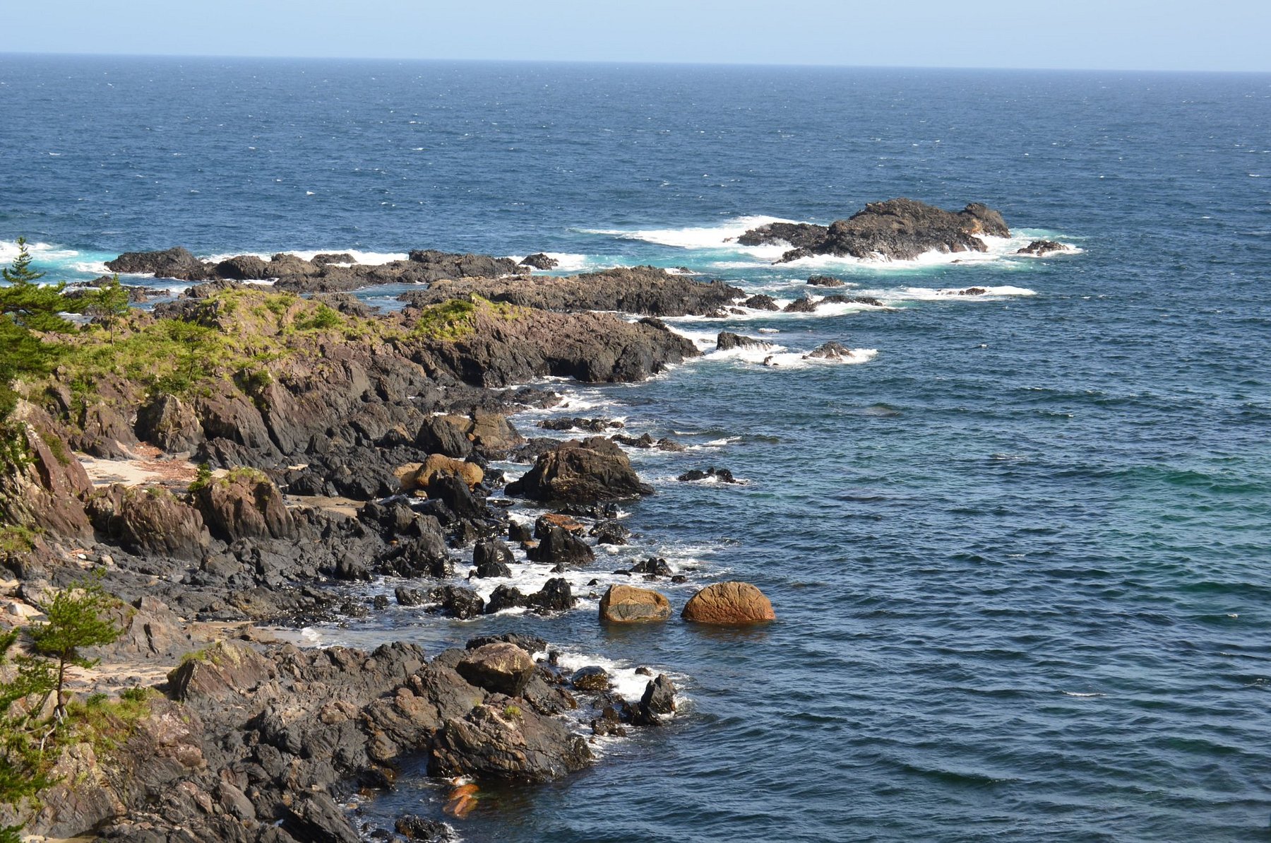
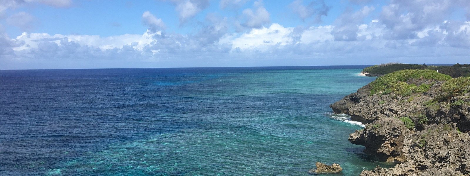
Contrasting Landscapes: Kamikoshiki and Nakakoshiki have gentle rolling hills and sandy spits, while Shimokoshiki features dramatic cliffs and rugged mountains, rising over 600 m .
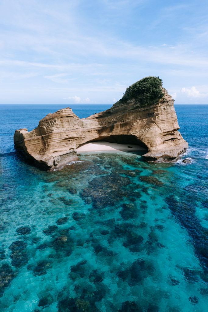
Nagame-no-Hama Sand Spit: A 4 km-long sandbar renowned for its beauty—one of Japan’s famous naturalscapes.
Napoleon Rock and Coastal Cliffs: Iconic sea stacks and steep cliffs ideal for sightseeing via boat cruises .
Tombolo Feature: The islands include one of Japan’s three major tombolos—sandbars connecting land masses.
Biodiversity & Birdlife: Recognized as an Important Bird Area, home to Japanese wood pigeons and notable for fossil-bearing cliffs dating to 80 million years ago.
Cultural & Historical Attractions
Koshikishima Villages: Traces of ancient habitation since the Jōmon and Nara periods, including samurai-era architecture in Shimokoshiki’s Teuchi district and religious customs like the Koshiki Daimyojin shrine built upon a cliff.
Bridges & Viewpoints: The Koshiki Bridge (2015) and Kanoko Bridge link the main islands and offer panoramic vistas from viewing decks like Bousetsu and Kinokuchi .
Cultural Traditions: Fossil cliffs, tombolo formations, and local festivals (e.g., UNESCO-recognized Toshidon on Shimokoshiki) reflect a rich island-based cultural heritage .
Activities & Itinerary
Cruising & Kayaking: Boat tours depart from Shimokoshiki, showcasing Napoleon Rock and coastal cliffs. Sea kayaking and snorkeling allow close-up nature interaction.
Diving & Snorkeling: Clear East China Sea waters reveal vivid marine life and underwater cliffs—ideal for beginners, too .
Scenic Hiking: Visit viewpoints like Tomekiyama (Kamikoshiki, 423 m) and Otake (Shimokoshiki, 604 m) offering sweeping seaside panoramas.
Camping & Art Workshops: Camp at seaside site on upper Shimokoshiki, enjoy stone-art sessions using local beach pebbles.
Local Eats & Culture
Seafood: Fresh kibi-nago fish, taka-ebi shrimp, oysters, and tuna are island specialties served in local eateries and featuring in signature dishes from fisher’s taverns to cafés .
Local Flavors: Enjoy salt products, passionfruit, aloe goods, kamaboko fish cake, Honkaku imo-shochu, and art‐burger—crafted around island ingredients .
Getting There & Stay
Access: Reach via high-speed ferry (≈50 min) from Sendai Port or regular ferry (≈70–75 min) from Kurino/Kushikino ports. Note: vessel departure is limited to two round-trips daily, so reservation is essential .
Island Transport: Minimal bus service—rent a car, bike, or scooter for easy exploration .
Best Seasons: Annual average temp ~18 °C. Peak flower seasons: June–July (silk trees, lilies), July–August (Kanoko lily), autumn/winter blooms include camellia .
Accommodation: Options include beachfront guesthouses, simple camping lodges, cafes with lodging near ferry terminals, and homestays in Teuchi and Sato hamlets .


")


")